


For thousands of years, skeptics dismissed the Garden of Eden as religious mythology with no basis in reality. Now, satellite technology has uncovered evidence that the biblical account may describe an actual location that once existed on Earth. Recent analysis of orbital scans has identified ancient, now-dry riverbeds that align with the specific geographical details recorded in the Book of Genesis—rivers whose very existence was doubted until space-age technology proved otherwise.
The Bible states unambiguously: “And a river went out of Eden to water the garden; and from thence it was parted, and became into four heads. The name of the first is Pishon: that is it which compasseth the whole land of Havilah, where there is gold; And the gold of that land is good: there is bdellium and the onyx stone. And the name of the second river is Gihon: the same is it that compasseth the whole land of Ethiopia. And the name of the third river is Hiddekel: that is it which goeth toward the east of Assyria. And the name of the fourth river is Euphrates” (Genesis 2:10-14).
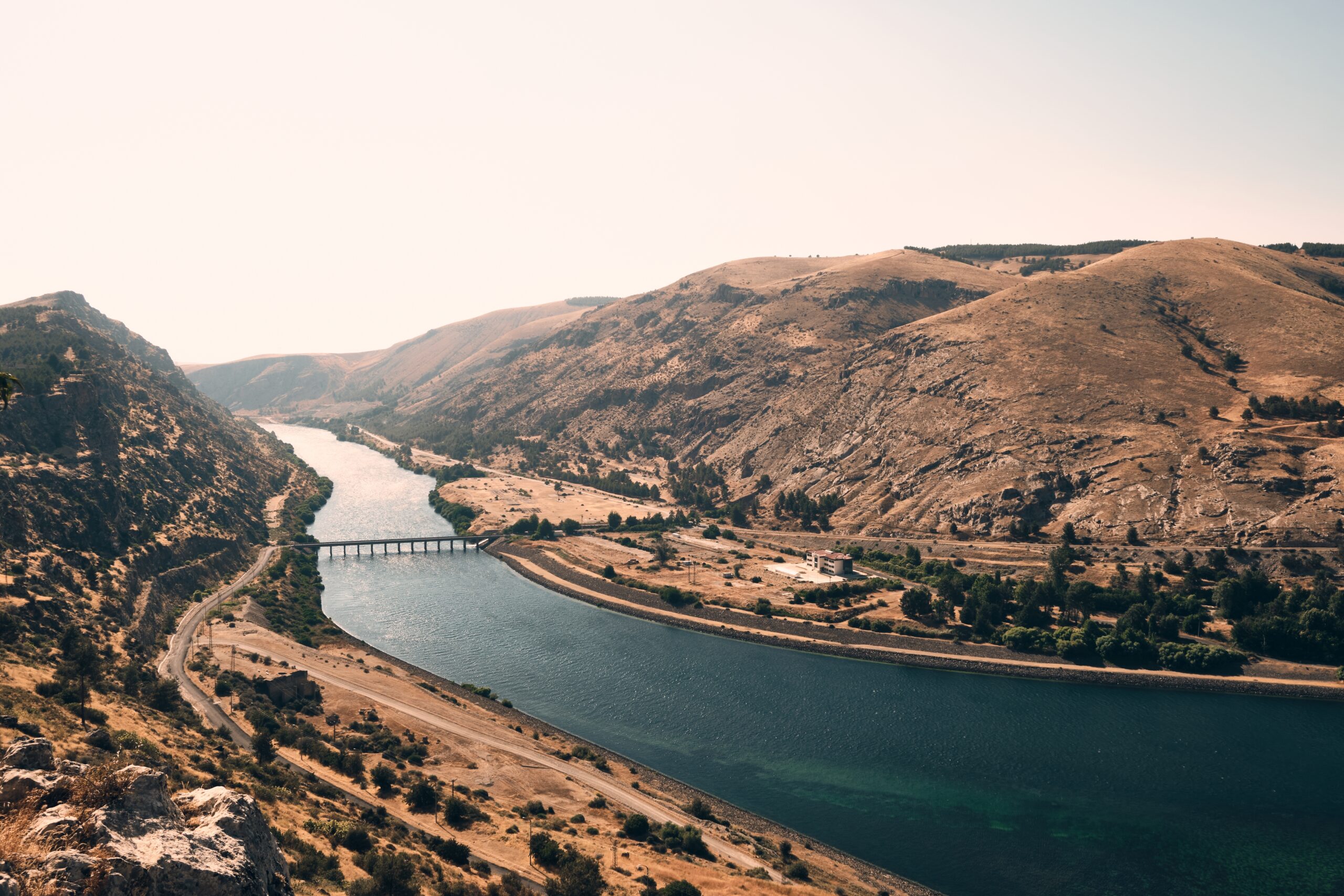
While the Tigris (Hiddekel) and Euphrates remain well-known rivers in modern Iraq, the Pishon and Gihon vanished from human knowledge millennia ago. That changed when Boston University geologist Farouk El-Baz analyzed radar images from NASA’s Space Shuttle Endeavor in the early 1990s. The images, revisited this month on Patheos, revealed a fossilized riverbed in Saudi Arabia up to three miles wide—a massive waterway that dried between 2000 and 3500 BCE when climate patterns shifted and Arabia became the desert it is today.
This ancient river, known as Wadi al-Batin, stretches from the western highlands of Hejaz, near Medina, northeastward to the northern Persian Gulf, near Kuwait. The geological evidence matches Genesis with precision: Wadi al-Batin’s path runs through a region rich in gold deposits, exactly as the biblical text describes Havilah. Modern satellite imagery captured the river’s delta near the Gulf, with sand dunes and depressions marking where water once flowed in abundance.
“These satellite images give us a window into landscapes that have vanished over millennia,” Dr. El-Baz explained. “We can now trace rivers that once shaped human settlement and perhaps even inspired ancient biblical narratives.”
The second lost river may also have been found. Iran’s Karun River, winding through the Zagros Mountains, corresponds to the biblical Gihon. The Hebrew word savav, meaning to circle or twist, describes the Karun’s serpentine path. The river historically flowed through Kassite territory, which some scholars identify as the land of Cush mentioned in Genesis. Together with the Tigris and Euphrates, these four rivers would have converged into the Persian Gulf, creating a fertile region that supported the earliest human civilizations.
Long-lost rivers of the Bible found in satellite images point to the Garden of Eden..🧐🤔
— UFO mania (@maniaUFO) February 9, 2026
It is fascinating how modern technology can breathe life into ancient texts. For decades, the "Garden of Eden" was considered purely metaphorical or lost to time, but satellite… pic.twitter.com/sLDF9tfeXg
James A. Sauer, a biblical archaeologist who studied satellite imagery, confirmed that Wadi al-Batin’s features match the biblical description of the Pishon more closely than those of any other known riverbed. Archaeologist Juris Zarins went further, stating that the satellite imagery showing ancient riverbeds near the Persian Gulf corresponds directly with Genesis descriptions, suggesting the Eden narrative reflects actual ancient geography.
Environmental data supports this conclusion. The data reveals Arabia’s transformation from a lush, river-fed landscape to an arid desert after the last Ice Age. Rising sea levels submerged portions of what may have been Eden’s river delta, erasing physical evidence that only space-based radar could recover. The ancient rivers’ courses align with archaeological findings of early farming communities and trade networks, offering a glimpse of the pre-flood world the Bible describes.
Not all scholars accept the Persian Gulf theory. Mahmood Jawaid, a chemical engineer in Texas, published a 2025 study arguing Eden was located in Bahir Dar, a fertile region in northwestern Ethiopia near Lake Tana, where the Blue Nile begins. Jawaid’s research, which has not been peer-reviewed, claims the Blue Nile corresponds to the biblical Gihon, and that Lake Tana’s multiple outflows could represent the four rivers of Genesis. He theorizes Adam and Eve lived in the Ethiopian highlands, about 6,000 feet above sea level, before descending to the East African Rift Valley. His study incorporates evolutionary theories about Homo habilis and Australopithecus, blending scientific speculation with Quranic interpretation.
Other scholars argue the land of Cush refers to African regions, connecting the Gihon to the Nile rather than the Karun. Some maintain that biblical texts blend spiritual meaning with historical memory, making exact geographical mapping impossible.
Yet the evidence from Wadi al-Batin stands. The satellite data reveals a physical reality that matches the biblical account with geographical precision. The Sages taught that the Torah speaks in the language of human beings—meaning it describes real places, real events, and real history. What space-age technology has revealed is that the biblical account of Eden’s rivers was not mythology or allegory, but an accurate description of an ancient world that existed exactly as Genesis recorded.
Jewish tradition records another mysterious river that will be discovered prior to the messianic era: the Sambatyon. According to Jewish literature, the ten lost tribes of Israel are hidden beyond this mythical river, separated from the rest of humanity. The Sambatyon has a unique characteristic—it does not flow on Shabbat. The lost tribes will remain in their hidden location until the final battle for Mount Zion, when they will return to help Israel.
The prophet Isaiah speaks of this return: “And in that day, a great ram’s horn shall be sounded; and the strayed who are in the land of Assyria and the expelled who are in the land of Egypt shall come and worship Hashem on the holy mount, in Yerushalayim” (Isaiah 27:13).
The Talmud (Sanhedrin 65b) relates how Rabbi Akiva referenced the River Sambatyon when explaining to the Roman governor Tineius Rufus why Shabbat is superior to any other day. Josephus Flavius, the first-century Romano-Jewish historian, wrote that Titus witnessed the River Sambatyon when he marched from Beirut to Syria, driving Jewish captives before him.
Just as satellite technology has now revealed the lost rivers of Eden, validating the biblical text, so too will the hidden river that conceals the lost tribes be revealed when the time comes for Israel’s final redemption. The rivers that disappeared from human knowledge are being found again—a sign that what was lost will be restored, and what was hidden will be revealed.