




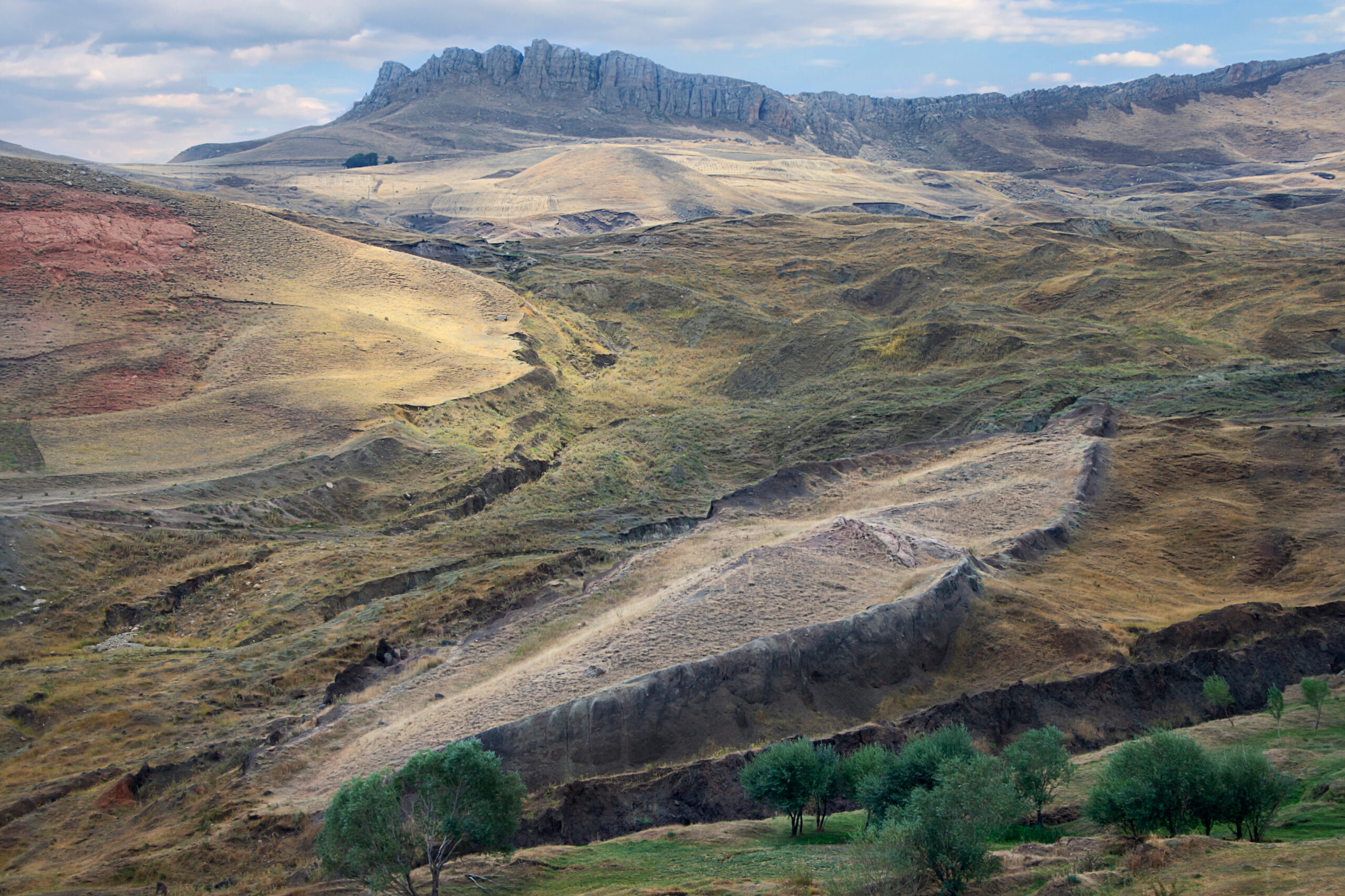
A boat-shaped formation in eastern Turkey has produced its most detailed underground readings in decades. Ground-penetrating radar equipment brought from the United States has detected multiple anomalies beneath the Durupinar formation in Ağrı province, including cavities and structures that intersect at right angles across several underground levels. Soil samples pulled from inside the formation have also shown carbon levels roughly 40 percent higher than samples taken outside it. Researchers say the combined data are pushing them toward answers that six decades of speculation have failed to produce.
The Sages treated the Genesis flood narrative as a record of real geography, not allegory, and the text itself supports that reading. After the water receded, “And the ark rested in the seventh month, on the seventeenth day of the month, upon the mountains of Ararat” (Genesis 8:4). Genesis continues with the same precision: “And the waters decreased continually until the tenth month; in the tenth month, on the first of the month, the tops of the mountains were seen” (Genesis 8:5). These verses give factual clues to the Biblical account, citing months, days, and a named mountain range. That level of specificity is precisely what has kept researchers returning to the region for over sixty years, and it is what now sends them underground with radar equipment rather than simply photographing a hillside from the air.
The Findings
The current excavation, led by archaeology professor Cenk Atilla of Sivas Cumhuriyet University, began fieldwork on June 28, 2026, near the Doğubayazıt district. Around 20 researchers and students from five countries have produced three-dimensional models of the formation, recorded GPS coordinates, and mapped the site before moving into underground surveys with radar systems also used by the U.S. Air Force.
“We tried to understand whether there are cavities, wood remains or other fragments underground that could have formed the shape of a ship,” Atilla told the Turkish newspaper Milliyet.
The scans identified what Atilla described as intersecting angular structures on multiple levels, converging toward the center of the formation. “The presence of anomalies and voids intersecting at a right angle raised the question of whether they could be part of a vessel,” he said. The team has begun collecting soil samples, with a target of roughly 1,000 total, to determine whether the elevated carbon readings point to organic material or decayed wood. “In the course of our studies, it has already been established that the quantity of carbon extracted from the inner part of the formation is 40 percent higher than from the outer,” Atilla said. “Already the current data daily raise[s] the probability that Noah’s Ark is here.”
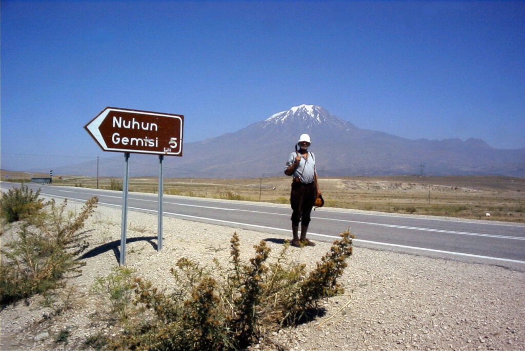
What the Formation Is
The Durupinar formation was first identified from aerial photographs in 1959 by Turkish army mapping officer İlhan Durupınar. Seen from above, it traces the outline of a large vessel, tapered at one end with a long central body, and measures approximately 164 meters in length. Turkey placed the site under protection in 1987 as a cultural and natural asset, though the government has never officially designated it as the site of the ark.
The dimensional argument has always been central to the case for Durupinar. Genesis gives the ark’s measurements directly: “This is how you shall make it: the length of the ark shall be three hundred amot, its width fifty amot, and its height thirty amot” (Genesis 6:15). An amah (plural amot) is the Biblical cubit, roughly 45 centimeters. At that standard, 300 amot comes to approximately 135 meters. Researchers working with the longer Egyptian royal cubit, about 52.4 centimeters, arrive at a figure closer to 157 meters, which lines up more closely with the measurements cited by the current research team. The comparison is suggestive, not conclusive, since ancient cubit standards varied and the formation’s own dimensions are measured differently depending on the source.
A Site Investigated for Decades
In 2019, a documentary team led by Cem Sertesen, who had spent 22 years searching for the ark, worked with computer engineer and archaeologist Andrew Jones and geophysicist John Larsen to scan beneath the formation using 3D imaging technology, sending electric signals underground through cables. “These are the actual images of the Noah’s Ark,” Sertesen told the Hurriyet Daily News. “They are neither fake nor simulation. They show the entire ship buried underground.” He added a caveat that has echoed through every subsequent phase of research: “It’s a ship, but it’s too early to call it Noah’s Ark. We have to do a lot of work.”
In 2021, a separate team conducted Electrical Resistivity Tomography, or ERT, surveys and reported finding what they described as a man-made boat structure beneath the ground.
A more formal academic study followed in December 2022, when a team from Istanbul Technical University, Andrew University and Ağrı İbrahim Çeçen University collected 30 soil and rock samples from the site. Their analysis, led by researchers specializing in geophysics, chemistry and geoarchaeology, dated human activity in the region to between 5500 and 3000 BCE. Professor Faruk Kaya, involved in that research, was careful to separate the dating from the ark claim itself. “With the dating, it is not possible to say that the ship is here,” Kaya said. “Extensive research is required for this to emerge.” The three universities agreed to continue joint research in the years that followed.
Andrew Jones’s continued involvement is notable. He now leads the research group Noah’s Ark Scans, whose 2026 radar work, carried out with Dr. Khosrow Bakhtar’s BakhtarRadar imaging system, produced the volumetric images of the underground structures reported this year. The site has moved, step by step, from a single aerial photograph in 1959 to electric-signal imaging in 2019, ERT surveys in 2021, dated soil samples in 2022, and now a multi-level radar map paired with nearly a thousand planned soil samples in 2026.
The Scientific Objection
Any claim about Durupinar has to answer a serious geological counter-argument. A 1996 peer-reviewed study in the Journal of Geoscience Education, authored by geologist Lorence G. Collins together with David Fasold, an explorer who had previously argued for the ark identification, concluded that the formation is a natural feature known as a doubly plunging syncline, a folded rock structure capable of producing an elongated, ship-like outline through ordinary erosion. Their analysis attributed earlier claims of iron fittings and petrified wood to volcanic rock and mineral deposits including limonite and magnetite.
Radar data alone cannot settle that dispute. Ground-penetrating radar measures reflections produced when electromagnetic waves meet materials of different density and composition; it can detect a cavity or an edge, but it cannot identify wood, stone, or metal without a physical sample. Carbon-rich soil is a similarly limited indicator on its own; elevated carbon does not establish age, and it does not by itself prove the presence of ancient timber.
The Bible is specific about what the ark was built from and how it was sealed. “Make yourself an ark of gopher wood; with rooms you shall make the ark, and cover it inside and out with pitch” (Genesis 6:14). That detail is exactly what makes the carbon and organic-material findings significant to researchers, and exactly what makes the absence of confirmed wood fragments significant to skeptics. Wood and pitch are the two materials any physical excavation at Durupinar would need to recover to move the site from anomaly to artifact.
Atilla’s team plans to move from radar mapping to targeted core drilling, which would allow physical samples and camera access to the cavities identified so far. Laboratory results on the current soil samples are expected within two to three months, with the full research program running through 2027.
The Larger Picture
The mountains of Ararat sit within the ancient region the Bible calls Ararat, generally identified with the historical kingdom of Urartu, a mountainous territory spanning a far wider area of eastern Anatolia than the single peak that carries the name today. Ararat also appears in the Bible as a real kingdom outside the flood account. The prophet Jeremiah, calling for nations to rise against Babylon, names it directly: “Set up a banner in the land, blow the shofar among the nations, prepare the nations against her, summon against her the kingdoms of Ararat, Minni and Ashkenaz” (Jeremiah 51:27). That geographic breadth is why multiple sites across the region, not only the volcanic peak known as Mount Ararat, have been proposed as the ark’s resting place over the centuries.
What sets the current study apart from the surveys that came before it is the scale of physical sampling now underway. A formation that has been debated for sixty years on the strength of its silhouette is, for the first time, being tested against nearly a thousand physical soil samples and a multi-level subsurface map.
An Older Flood Story
The Bible is not the only ancient Near Eastern text to preserve a flood account. The Epic of Gilgamesh, a roughly 4,000-year-old work from Mesopotamia and among the oldest surviving pieces of epic literature, tells a similar story. Only a handful of tablets survive. In it, King Gilgamesh meets Utnapishtim, who has been granted immortality, and asks him how he obtained it. Utnapishtim answers by recounting a flood he survived.
Five gods of the Mesopotamian pantheon — Anu, Enlil, Ninurta, Ennugi and Ea — decided to flood the earth and swore themselves to secrecy. Ea broke that oath indirectly, speaking the plan through a reed wall of a reed house so that Utnapishtim overheard it rather than being told outright. Ea instructed him to tear down his house and build a boat regardless of cost, specifying exact dimensions: 120 cubits square, with six decks, sealed with pitch and bitumen. Utnapishtim assembled craftsmen and built the vessel, fitted with a rudder and punting poles. When it was finished, he held a feast, then loaded it with his family, his craftsmen, “all the animals of the field,” and stores of gold and silver.
A storm broke out and lasted six days and nights, terrifying even the gods, who retreated to the heavens. The goddess Ishtar mourned the destruction of humanity, and the other gods wept beside her. By the time the storm ended, the text says “all the human beings turned to clay.” Utnapishtim’s boat came to rest on Mount Nimush. He released a dove and a swallow, both of which returned, and then a raven, which did not — a sign that dry land had been found — the same sequence of birds used in the Genesis account. He then opened the boat and let out everyone and everything aboard.
Utnapishtim offered a sacrifice, and the gods, drawn by the smell, “crowded around it like flies.” Ishtar vowed she would remember the flood forever. Enlil, arriving and seeing survivors, grew angry, and Ea was accused of leaking the gods’ plan. Ea countered that the flood had been a punishment disproportionate to mankind’s offense. Enlil relented, blessed Utnapishtim and his wife, and granted them eternal life.
The differences matter more than the similarities. In the Gilgamesh Epic, the gods send the flood because the noise of a growing human population disturbs their sleep, and afterward institute measures to limit population growth; Utnapishtim’s reward is personal immortality granted by a repentant god. In Genesis, the flood comes as a response to human wickedness, not noise or overcrowding, and Noah is saved for his righteousness rather than granted immortality. What follows the flood is not a private reward but a covenant binding every nation descended from him.
The Covenant That Followed
Renewed interest in the ark’s remains carries meaning beyond the question of archaeology. It stands as a reminder that mankind entered into a binding covenant with God the moment Noah stepped off that vessel, one that has never been revoked and continues to carry obligations today.
When Noah and his family emerged, God established a covenant that extended beyond them to every nation that would descend from them. “I now establish My covenant with you and with your descendants after you” (Genesis 9:9). That covenant carried binding obligations. “Whoever sheds the blood of man, by man shall his blood be shed; for in the image of God He made man” (Genesis 9:6) is one of them, and the Sages identified seven such laws in total, incumbent on all of humanity and not on the nation of Israel alone. The Sages traced each one to the text of B’reshit, Genesis, itself: the prohibition against murder to Genesis 4:23-24 and 9:6, the prohibition against idolatry to Genesis 4:26, the prohibition against blasphemy to Genesis 4:26, the prohibition of sexual immorality to Genesis 1:28, 4:22, 6:3 and 6:12, the obligation to establish courts of justice to Genesis 1:28 and 9:6, the prohibition against theft to Genesis 6:11, and the prohibition against eating the limb of a living animal to Genesis 9:4. These are known as the Sheva Mitzvot Bnei Noach, the Seven Laws of the Descendants of Noah, or the Noahide Laws. Unlike the 613 commandments given later at Sinai, which apply specifically to the Jewish people, the Noahide Laws are understood by the Sages to apply to every human being alive today, Jew and non-Jew alike, as descendants of the man who survived the flood.
The text in Genesis names a mountain range, a month and a day. Whether the ground beneath Durupinar holds a vessel or simply another fold of ancient rock, the researchers digging there in 2026 are testing a claim the Bible made in specific enough terms to be testable at all.
If the findings at Durupinar are confirmed, they will prove the historical accuracy of the Biblical account of the flood in the time of Noah, which describes the ark’s final resting place as the mountains of Ararat.
