


For decades, the Gilgal Refaim — the Wheel of Giants — stood as one of the ancient world’s great riddles, a colossal circle of 40,000 tons of basalt rock on the Golan Heights that seemed to belong to no known civilization and served no agreed-upon purpose. Scholars called it unique. They were wrong.
A new study published in the prestigious peer-reviewed journal PLOS ONE has entirely upended that assumption. Using high-resolution satellite imagery collected over two decades — from 2004 through 2024 — a multidisciplinary team of Israeli and international archaeologists and physicists identified 28 large circular stone structures within a 25-kilometer radius of Gilgal Refaim, all sharing striking architectural similarities with the famous site.
This discovery forces a fundamental rethinking of who built these structures, why, and what they tell us about the people who walked this land thousands of years before the modern world arrived.
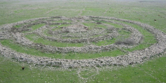
Gilgal Refaim — which Arabs call Rujm el-Hiri, the “stone heap of the wild cat” — was first spotted in 1968 through military aerial photography taken after the Six-Day War. From the ground, it looks like random piles of basalt rock. From above, it is revealed to be five concentric rings of stone, the outermost stretching more than 152 meters across, with a central burial mound over 20 meters in diameter and five meters tall. Estimates place its construction between 3,500 and 6,500 years ago, in the Chalcolithic or Early Bronze Age. For context, it may have been built around the same time as Stonehenge in England.
“Gilgal Refaim is, of course, a very well-known site, and it was always considered to be a very unique site in the area,” said Michal Birkenfeld of the Department of Archaeology at Ben-Gurion University of the Negev, one of the study’s authors. “Most [of the sites we discovered] were not as elaborate and were of different sizes and levels of preservation, but they still have the same type of logic.”
The research team’s methodology was itself groundbreaking. Rather than relying on ground surveys — expensive, time-consuming, and limited by terrain — they layered satellite images from multiple platforms, including Google Earth Pro and CNES/Airbus, cross-referencing the same areas across years and processing them to cut through seasonal vegetation, shadows, and surface noise. The result was a map revealing ancient human construction that had been hidden in plain sight.
The astronomical observatory theory, once popular — based on the site’s alignment with the summer solstice sunrise and markers for the equinoxes — was already dealt a serious blow by a 2025 paper co-authored by Birkenfeld, which showed that the site had shifted and rotated at an average of 8 to 15 millimeters per year due to geological movement. That means the structure has drifted tens of meters since its construction, making the original astronomical alignments unreliable as evidence of intent.
Birkenfeld now leans toward a more functional explanation. “If this is not a unique structure, I find more leverage in the idea that this was an area to get together,” she said, pointing to the phenomenon of seasonal gatherings common in nomadic societies — communities otherwise spread across the region converging at a central point.
The Bible itself offers a clue hiding in the name. The Hebrew Gilgal Refaim — Wheel of the Refaim — carries enormous weight in Scripture. The Refaim were a race of giants who inhabited Canaan before the Israelites arrived. Og, the king of Bashan — the very region where Gilgal Refaim stands — is described in Deuteronomy as the last survivor of this race:
“Only King Og of Bashan was left of the remaining Refaim. His bedstead, an iron bedstead, is now in Rabbah of the Ammonites; it is nine amot long and four amot wide, by the standard amah.” (Deuteronomy 3:11)
An amah — literally the length of a forearm, approximately 19.2 inches — places Og’s bed at over fourteen feet long and six feet wide. The Prophet Amos described the Amorites, the broader group to which the Refaim belonged, as men whose “stature was like the cedar’s” (Amos 2:9). The Sages add another layer: Midrash identifies Og as the man who survived Noah’s flood by clinging to the side of the Ark, making him, if the tradition is taken seriously, an ancient figure of almost incomprehensible age and size.
If a nation of such giants once dominated the Golan — building massive stone structures across a 25-kilometer radius — the archaeological record now being uncovered through satellite imagery fits that biblical picture with startling precision. A single monument built by an unknown people is a curiosity. Twenty-eight such monuments concentrated in one region are the signature of a civilization.
“What we could learn from remote sensing is form, size, and location,” Birkenfeld said. “Now we need traditional archaeology so we can talk about activities and chronology. Only when we know what they did in these structures and when they did it, will we really have the entire wide plethora of information that we need to start hypothesizing on what those sites meant.”
“This paper is really just the beginning of a project rather than the end of it,” she added.
The Golan Heights — land that Israel liberated in 1967 and formally applied sovereignty over in 1981 — is not merely strategic high ground. It is a landscape inscribed with thousands of years of history, a biblical territory where giants once walked, where Jacob and Laban set their boundary stone, and where the people of Israel now live and farm.