


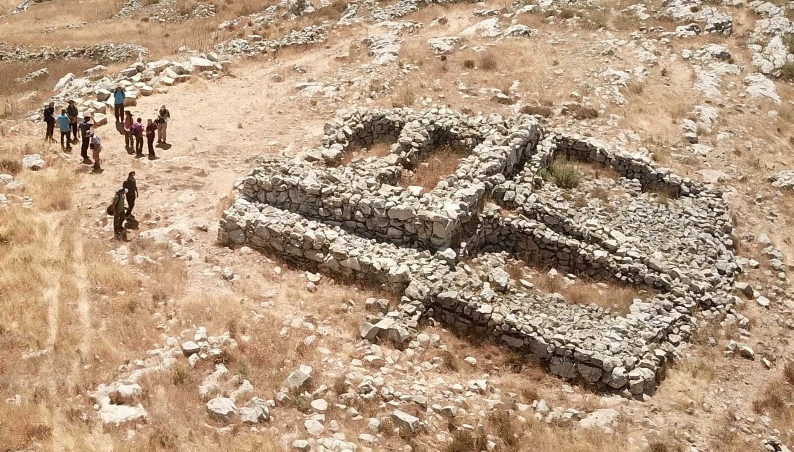
When Professor Adam Zertal discovered Joshua’s Altar in the 1980s, he encountered a problem: Mt. Gerizim is not visible from the altar location.
Furthermore, if the ceremony, described in Deuteronomy 27 and Joshua 8, took place on the slopes of the valley of Shechem, why did the Israelites choose to build the altar and the foot enclosure surrounding it 1.5 miles away on a remote slope facing eastward?
This caused many to doubt that this is indeed Joshua’s Altar. Zertal’s solution was to relocate Mt. Gerizim to the west of Mt. Ebal to a mountain now called Mt. Kabeer, thus canceling 2,500 years of Samaritan tradition.
I would like to propose another solution that might explain the decision to build the altar facing eastward.
Where to?
If you ever saw a group of Jews about to start praying in an airport in New York and wondered why they are shouting “where to?” or pointing with their hands while moving their lips, you should know that a pre-prayer debate is going on as to the right direction to face while praying.
Religious Jews convene and pray three times a day. For the prayer to start, everyone needs to know where Jerusalem is and face it. Since the destruction of the Second Temple in Jerusalem in the year 70 AD, Jews all over the world have faced Jerusalem and directed their intent toward the place where the house of God used to be located.
As a lover and reader of the Bible, I always wondered, which direction did the ancient Israelites face to worship and sacrifice BEFORE Jerusalem was established as the principal place of worship?
Was there an agreed direction to begin with at every period? If there was a direction for worship, what was it at the time of the conquest?
Getting answers would require me to visit and focus on the earliest worshiping sites of the Israelites, known today as The Gilgals (Foot Structures) and the Mt. Ebal altar, also known as “Joshua’s Altar.”

The Holy Compounds
For the past 15 years, I’ve been involved in the archaeological research of Samaria and the Jordan Valley, known as the Manasseh Hill Country Survey (MHCS) founded by the late Professor Adam Zertal and headed today by Dr. Shay Bar.
These areas, which previously had never been archaeologically surveyed, have yielded hundreds of new sites that were unknown until the survey’s work commenced.
My main interest was newly discovered cultic sites from the Early Iron Age period that were found thanks to the Survey’s rigorous and meticulous work. These sites would constitute the majority of sites that were in use by Israelites during the time of Joshua, Judges, and 1&2 Samuel.
Zertal and his crew discovered six compounds that were believed to be cultic sites belonging to the Israelite culture:
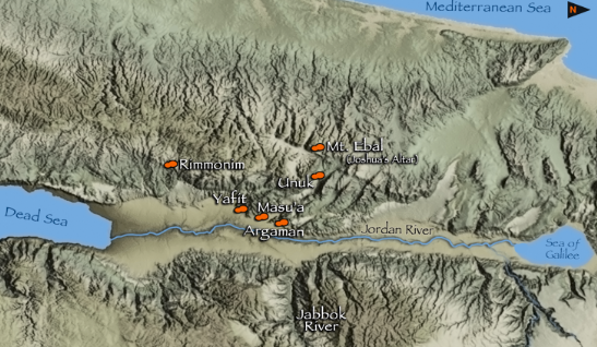
- Argaman (Baydat El Sha’Eb)
- Masu’a (Masu’a 4)
- Yafit
- Unuk – Tirzah / Faraa valley
- Ebal surrounding Joshua’s Altar
- Rimmonim (Shaeb Romani)
These sites were identified by Zertal in his book The Footsteps of God 1 as Gilgals, oval shaped stone compounds that served as places of gathering for the Israelite tribes in the initial stages of the conquest period. The Bible describes Gilgals as places used for worship, sacrificing, and circumcision, but also as war camps and sites for crowning kings. In that sense, Gilgal is not just a worshiping site. It is also a place of national or tribal significance. We read about their existence in the Bible from Joshua to the Prophets, and indeed, according to the archaeological evidence, some of these compounds served the Israelites for hundreds of years, only ending with the Assyrian destruction of 722 BC.
Why are these enclosures identified as cultic and Israelite? Dr. Ralph Hawkins speaks in length about the criteria for defining what is a cultic site and characterizing Israelite cultic sites specifically. I highly recommend reading his books to better understand the basis for his conclusions2.
For the purpose of this article, I would like to move forward based on the understanding that these are indeed Israelite cultic structures. The more recent discovery of the Mt. Ebal Curse Inscription is a very important archaeological achievement in itself. The fact that the tablet’s origin was one of these six-foot structures makes it even clearer that all six compounds belonged to the Israelite culture and theology. In assessing the issue in hand, I tried to look for clues as to the orientation of worshiping among the six structures located at Argaman, Masu’a, Yafit, Unuk, Ebal, and Rimmonim.
Dead End
Every time Zertal presented the discovery of the foot enclosure compounds to an audience, the participants always tried to look for common ground. The focus was always the compound’s direction, location, and architecture.
If these structures were foot-shaped, which foot was it, right or left? Why are the structures foot-shaped? What is the significance of their shape? What was the consideration in placing the structures in those specific geographical locations?
Although the structures had in common an oval shape to their design, the problem was they seemed to have been built facing in different directions. Their architecture was also slightly different: some had procession roads, some had an altar or Bamah (cultic high ground), some had inner divisions.
My main question was with their differing directions, and it seemed like I couldn’t find a single direction that would connect all six structures.
I decided to take another approach: Divide and Conquer. These were conquest sites, after all.
The Jordan Valley Enclosures
The first group of structures in my view were the three enclosures in the Jordan Valley: Yafit, Masu’a, and Argaman. The reason why I grouped them together was because of their proximity and the fact that they are in the same geographical zone – the Jordan Valley – and to be more specific, the opening of the Tirzah Valley also known in Arabic as Wadi Faraa.
Concentrating on these foot structures, I couldn’t find a shared direction. Furthermore, the Masu’a structure was never excavated and was unintentionally destroyed while building an industrial zone, so the only knowledge I had was the Survey’s sketches and description.
The Yafit enclosure wasn’t very helpful either, because of the unclear direction the enclosure faces. To speak the truth, the shape doesn’t really look like a foot in comparison to the Argaman foot structure.
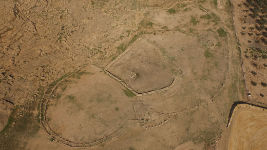
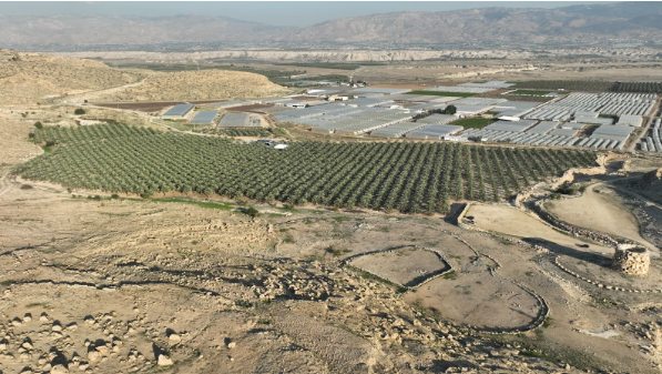
I remembered visiting the Argaman structure and trying to figure out how the worship might have looked thousands of years ago, but it was really all a guess. I was stuck again. I sat on the slopes of the mountain adjacent to the Argaman foot structure, and looked with frustration into the distance.
I realized that we sometimes tend to focus on the wrong things. What I suddenly saw in the distance changed everything!
It’s the Théâter Stupid!
All three Jordan Valley compounds have a natural slope that is adjacent to them. This slope would have been the place where the Israelites sat, or stood, while watching the ceremonies taking place in the foot enclosure.
The great thing about the location of the slopes is that the direction to which the crowd faced was now noticeably clear to me. The slope was like a natural theater. The natural ascent made the direction of worship focus evident. The reason why I had never considered the adjacent slopes was because the enclosure itself was always the focus of the research, and I always believed that the central focus of the audience was only the events taking place in the enclosure.
But what if the whole orientation of the site was not dependent on the location of the enclosure? What if the common factor between the Jordan valley compounds was the direction that the Israelites faced while watching the ceremonies taking place in the foot enclosure? To check this possibility, I had to revisit the other two sites and check the orientation of the natural theaters.
If I did find a shared direction or location that all three Jordan Valley theaters are facing, I might be able to connect it to the other enclosures and possibly solve the orientation question of the altar on Mt. Ebal.
North, South, East or West?
Revisiting the three sites at the Jordan Valley, it was evident that the three theaters had different orientations. That ruled out the Four Winds. If there was a common direction, it had to be something else.
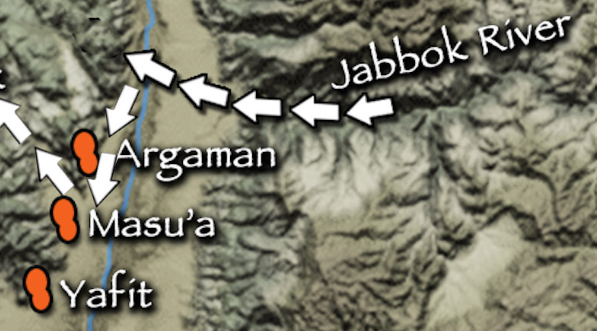
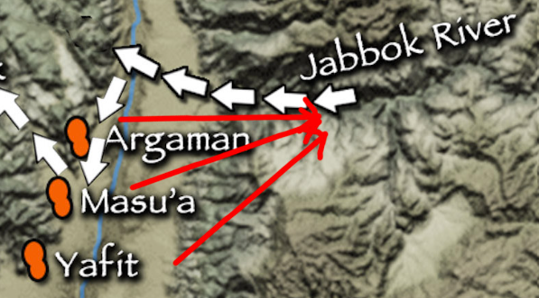
Using a map marking each of the 3 Jordan Valley foot structures and their adjacent theaters, I drew three lines starting at each of the theaters, through each of the enclosures, and continuing straight into the distance as if a person standing on each of the slopes was looking straight out into the distance from each line’s starting point.
All three lines crossed at the same location – the Jabbok or Yabok River, or in Arabic, Wadi Zarkaa and the plain of Adam.
During the conquest period, the Yabok River separated between the tribe of Gad in the south and the Half Tribe of Manasseh in the north (The Gilead). At the area where the river flows into the Jordan is Tel El Damia, the ruins of the ancient city of Adam. If all three theaters pointed in this direction, it could not be a coincidence. What was so significant about this area in the eyes of the Israelites?
PART 2 OF THIS ARTICLE WILL BE PUBLISHED SOON

